Why Panorama Ridge Is Breaking the Internet (And What Northern Ontario Explorers Need to Know)
Panorama Ridge has exploded across social media feeds in 2026, drawing thousands to British Columbia’s Garibaldi Provincial Park where a new permit lottery system now limits access to just 60 hikers per day. The 10-kilometer trail to its windswept summit offers postcard-perfect views of turquoise Garibaldi Lake, but what was once a challenging day hike has become a logistical headache of permit applications, early-season road closures, and overcrowded parking lots.
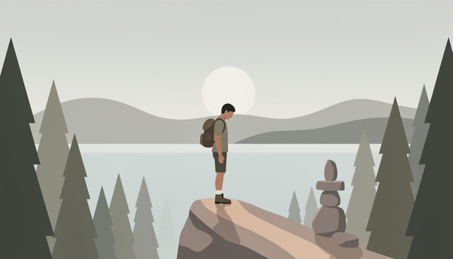
If you’re captivated by the promise of alpine ridgelines and sweeping vistas but frustrated by BC’s permit bottlenecks, Northern Ontario holds equally dramatic hiking experiences without the crowds or bureaucracy. The Canadian Shield’s ancient bedrock creates ridge systems older than the Rocky Mountains, where you’ll walk on billion-year-old granite beneath expansive northern skies. These trails wind through territories stewarded by Anishinaabe, Cree, and Ojibwe peoples for millennia, offering opportunities to connect with Indigenous-led tourism experiences that deepen your understanding of the land.
Unlike Panorama Ridge’s fragile alpine meadows suffering under thousands of boots each summer, Northern Ontario’s trail networks practice sustainable recreation. You’ll find solitude on ridgelines where a dozen hikers constitute a busy day, where your permit fees directly support conservation partnerships with First Nations communities, and where the journey matters as much as the summit view. The Shield country rewards those willing to venture beyond the Instagram hotspots with wilderness experiences that feel genuinely wild.
The Panorama Ridge Phenomenon: What’s Driving the Hype
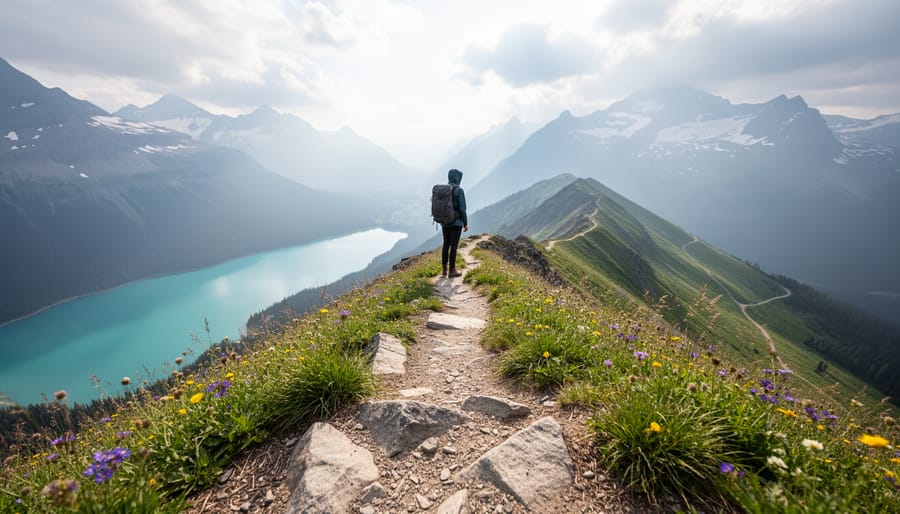
Panorama Ridge has become the BC hike everyone’s talking about in 2026, and it’s not hard to see why. This 32-kilometer round-trip adventure in Garibaldi Provincial Park, just south of Whistler, delivers what every Instagram feed craves: turquoise alpine lakes, wildflower meadows that stretch to the horizon, and jaw-dropping views of glaciated peaks including Black Tusk and Mount Garibaldi. Hikers who make the steep push to the ridgeline are rewarded with 360-degree panoramas that feel almost unreal, the kind of landscape that stops you mid-step and makes you forget your aching legs.
But the hype goes beyond scenery. Social media algorithms love this trail. A single post from Panorama Ridge can rack up thousands of likes, and that viral momentum creates a feedback loop: more posts mean more people adding it to their bucket lists, which means even more posts. The trail has become shorthand for “epic wilderness adventure,” and in 2026, everyone wants a piece of that narrative.
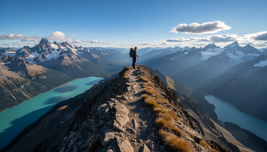
There’s a catch, though. BC Parks implemented a strict permit quota system running through at least December 31, 2026, requiring advance reservations through camping.bcparks.ca for overnight stays at Garibaldi Lake or Taylor Meadows campgrounds. You can’t camp anywhere else on this route, only on designated tent pads, and permits vanish within minutes of becoming available. This scarcity has turned the hike into something of a Holy Grail, with hikers refreshing booking pages at midnight and sharing permit-scoring strategies like they’re concert tickets.
The quota system exists for good reason: protecting fragile alpine ecosystems from being loved to death. But it’s also created an unintended side effect. The harder something is to access, the more people want it. Panorama Ridge isn’t just trending because it’s beautiful. It’s trending because getting there feels like winning a lottery.
Northern Ontario’s Answer: Ridge Hikes That Rival the West Coast
The Sleeping Giant’s Ridgeline: Ontario’s Crown Jewel
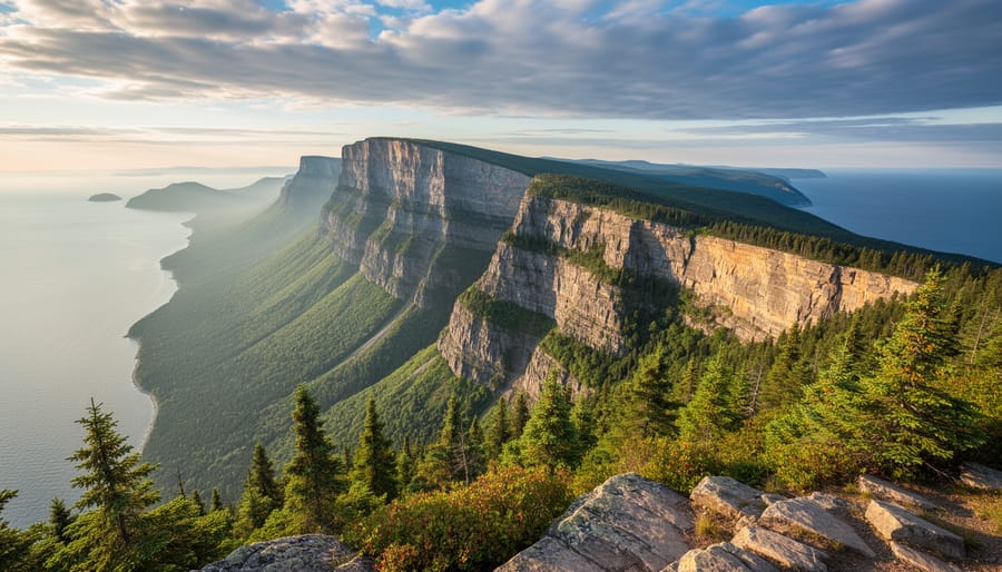
The Top of the Giant trail is Northern Ontario’s answer to Panorama Ridge’s alpine drama, delivering 22 km of challenging terrain that culminates in the most spectacular lake view in Ontario. This demanding out-and-back route ascends 250 metres through boreal forest before breaking out onto exposed ridgeline where Lake Superior sprawls 300 metres below in an endless expanse of cobalt blue.
But the Sleeping Giant is far more than a hiking destination. To the Ojibwe people, this massive peninsula formation represents Nanabijou, the Spirit of the Deep Sea Water, who lies in eternal slumber guarding the lake’s silver deposits. According to tradition, Nanabijou was turned to stone after the secret location of a silver mine was revealed to outsiders, transforming him into the giant figure visible from Thunder Bay’s shoreline. Walking this ridge means treading on sacred ground that has held spiritual significance for countless generations.
What sets this experience apart from BC’s crowded trails is the profound sense of solitude. You can spend hours on the Giant’s head without encountering another soul, especially on weekday visits. The exposed ridgeline offers that same edge-of-the-world feeling that drives hikers to Panorama Ridge, with sheer cliffs dropping dramatically to Superior’s waters and views stretching 80 km on clear days. The trail demands respect: weather shifts rapidly, exposed sections leave you vulnerable to wind, and navigation requires attention. It’s a legitimate wilderness experience that rewards preparation with memories that rival any West Coast summit.
Cup and Saucer Trail: Manitoulin’s Hidden Panorama
The Cup and Saucer Trail on Manitoulin Island delivers the kind of jaw-dropping vistas that make Panorama Ridge famous, but in a more accessible 7.8 km package. The Niagara Escarpment’s white cliffs rise 70 meters above Lake Huron, offering sweeping views that stretch across the North Channel to the mainland on clear days. What sets this trail apart is its layered history: the escarpment holds deep spiritual significance for the Anishinaabe people who have called Manitoulin home for millennia, and the land itself represents the world’s largest freshwater island. The loop takes most hikers three to four hours, with a dramatic ladder climb rewarding you with 360-degree panoramas that rival anything the Rockies offer. Wildflowers blanket the exposed ridgeline in June and July, while autumn transforms the hardwood forests below into a riot of colour. Unlike BC’s permit lotteries, you can simply show up and hike, though respecting the trail’s cultural context means treading lightly on land that remains central to Anishinaabe identity and connection to place.
Backcountry Ridge Routes: For the Adventurous
For those who find even Sleeping Giant too tame, Northern Ontario’s true backcountry offers ridge systems that demand serious navigation skills and self-reliance. Wabakimi Provincial Park’s rugged quartzite ridges provide multi-day routes where you’ll encounter more moose than people, threading through ancient rock formations that predate most mountain ranges. Quetico’s Height of Land portage crosses a continental divide with sweeping views across interconnected waterways, rewarding paddlers willing to haul their gear to ridge-top vantage points. Pukaskwa National Park’s coastal ridges along Lake Superior deliver dramatic elevation changes where boreal forest meets the world’s largest freshwater sea. These routes require topographic map skills, wilderness camping experience, and genuine comfort with solitude. No Instagram crowds here, just you, the shield rock, and thousands of square kilometers of roadless wilderness that make BC’s permit quotas seem like a distant concern.
What BC’s Permit System Teaches Us About Sustainable Trail Access
Garibaldi Provincial Park’s reservation system offers a masterclass in managing wilderness under pressure. Through camping.bcparks.ca, BC Parks enforces strict backcountry camping quotas at Garibaldi Lake and Taylor Meadows, the staging grounds for Panorama Ridge. Hikers must reserve designated tent pads months in advance, and camping outside these approved sites is prohibited. The system runs through 2026 and beyond, protecting fragile alpine meadows from the trampling that comes with viral fame.
This isn’t bureaucracy for its own sake. Alpine environments recover slowly. A single bootprint through delicate heather can take decades to heal. By capping overnight numbers and containing campers to hardened tent pads, BC Parks prevents the social trail proliferation and vegetation loss that plagued popular routes before quota systems existed. Hikers still get their summit experience, ecosystems get breathing room, and the trail remains viable for future generations.
Northern Ontario is watching and adapting. While the region’s ridge systems haven’t yet faced Panorama-level crowds, parks managers are implementing similar frameworks before problems emerge. Sleeping Giant Provincial Park now requires advance registration for backcountry campsites during peak season, and Pukaskwa National Park maintains strict camping zones in its coastal wilderness. These measures reflect lessons learned out west: proactive management beats reactive damage control.
The broader principle matters beyond specific parks. Quota systems acknowledge that wilderness isn’t limitless, that access and preservation exist in tension. For Anishinaabe stewards who’ve maintained relationships with these lands for millennia, this approach aligns with traditional practices of seasonal use and giving landscapes time to rest. Modern permit frameworks, when designed respectfully, can reinforce rather than replace indigenous land management wisdom.
As Northern Ontario’s hiking culture matures and social media spotlights once-obscure trails, expect more reservation requirements. Smart hikers plan ahead, respect quotas, and recognize that a little advance booking preserves the wildness they came to experience. The alternative is loved-to-death trails nobody wants to visit anymore.
Planning Your Northern Ontario Ridge Adventure for 2026
Timing Your Visit: Seasonal Considerations
Northern Ontario’s ridge hiking season runs from mid-June through late September, with each period offering distinct rewards. July and August deliver the most stable weather and full trail access, but early summer holds a special appeal for those chasing that Panorama Ridge aesthetic: lingering snowfields on north-facing slopes create dramatic contrast against emerging wildflowers, and you’ll find patches of snow well into July on higher ridges like the Sleeping Giant.
Wildflower enthusiasts should target late June through mid-July, when alpine meadows explode with Indian paintbrush, fireweed, and wild lupine. The shoulder seasons, early June and late September, bring fewer crowds and striking light for photography, though you’ll face cooler temperatures and the possibility of early or late-season snow. Pack layers regardless of when you visit; ridge-top weather shifts quickly in the North, and what starts as a warm morning can turn brisk once you’re exposed on the ridgeline. September offers bonus fall colours at lower elevations, transforming your descent into a gallery of crimson and gold.
Backcountry Camping Essentials
Northern Ontario’s backcountry camping operates on a reservation system similar to BC’s, with designated sites at provincial parks protecting sensitive ecosystems. Review our safety tips and packing tips before departure, and source your camping supplies locally when possible to support communities near trailheads.
Leave No Trace takes on deeper meaning here. These lands have sustained Anishinaabe communities for millennia through careful stewardship practices. Pack out everything, use established fire rings only where permitted, and avoid disturbing culturally significant sites like pictograph locations or ceremonial areas.
Bear safety is non-negotiable. Black bears are common throughout the region. Hang food properly using the rope method or bear canisters, cook away from your tent, and never store scented items inside. Make noise on narrow ridge sections where sightlines are limited. If you encounter a bear, back away slowly while speaking calmly. Understanding these basics transforms a potentially dangerous situation into a manageable one, letting you focus on those ridge-top sunrises that rival anything the West Coast offers.
Getting There: Access Points and Logistics
Most Northern Ontario ridge trails require several hours of driving from major centers, making advance planning essential. Thunder Bay serves as the gateway to Sleeping Giant Provincial Park, with the trailhead accessible via a 45-minute drive along Highway 587. Manitoulin Island’s Cup and Saucer Trail sits roughly two hours from Sudbury, reachable via Highway 6 and the swing bridge.
For remote destinations like Wabakimi and Pukaskwa, consider partnering with local outfitters who operate with respect for traditional territories and can provide shuttle services, canoe rentals, and backcountry guidance. Many indigenous-owned operators offer culturally informed trips that honor the land’s history. Book transportation and lodging well ahead during peak summer months. Cell service disappears quickly outside towns, so download offline maps and inform someone of your itinerary before heading into the backcountry.
The Cultural Landscape: Hiking With Respect
Every ridge trail in Northern Ontario crosses living territories where Indigenous culture has shaped the land for thousands of years. The Sleeping Giant rises from Anishinaabe territory, the Cup and Saucer overlooks Manitoulin’s Odawa and Ojibwe communities, and backcountry routes through Wabakimi and Quetico traverse Oji-Cree and Cree homelands where families still hunt, fish, and gather medicines today.
Before you step onto any trail, take time to learn whose traditional territory you’re entering. Simple gestures carry weight: pack out everything you bring in, stay on designated paths to protect plant species used in traditional practices, and never disturb rock cairns or pictograph sites that mark culturally important spots. When you encounter berry patches or fishing areas, remember these resources sustain local families, not just wildlife.
Hiring indigenous guides transforms a hike from a photo opportunity into genuine understanding. Organizations like the Anishinaabe-led guides at Sleeping Giant Provincial Park and Manitoulin Island operators offer trips that weave stories about the land’s history, traditional navigation techniques, and seasonal patterns their ancestors observed for generations. At Pimachiowin Aki a UNESCO World Heritage Site protecting over four million acres of boreal forest, you can join community-led expeditions that demonstrate jiikendaaswin (the keeping of knowledge) through direct experience.
Supporting these guides means trail fees stay within the communities managing these lands, reinforcing the connection between conservation and cultural survival that makes Northern Ontario’s wilderness experiences richer than any permit system alone could achieve.
The Panorama Ridge buzz sweeping across social feeds in 2026 carries a valuable lesson: people crave raw, unfiltered encounters with dramatic landscapes that take effort to reach. But you don’t need to join the BC permit lottery or battle for camping spots to experience that alpine high.
Northern Ontario’s ridge systems deliver everything that made Panorama Ridge famous, sweeping vistas, challenging scrambles, genuine wilderness solitude, often without the crowds crushing Garibaldi Provincial Park. The Sleeping Giant’s ridgeline offers views just as breathtaking. Cup and Saucer Trail rewards you with 360-degree panoramas across Lake Huron. Backcountry routes through Wabakimi and Pukaskwa provide the kind of solitude that’s increasingly rare in our hyperconnected world.
What matters now is how we approach these places. The permit systems protecting BC’s alpine zones aren’t bureaucratic hassles; they’re acknowledgments that wilderness has limits. Northern Ontario is adopting similar frameworks, balancing access with preservation. More importantly, hiking these ridges means walking through Anishinaabe, Cree, and Oji-Cree territories with awareness and respect.
The future of wilderness travel isn’t about chasing the next viral destination. It’s about exploring responsibly, learning the cultural stories embedded in these landscapes, and recognizing that the most rewarding adventures often wait in your own backyard. Northern Ontario’s ridges are ready when you are.